


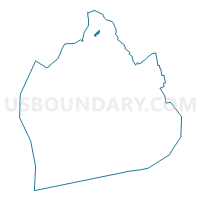
Voting District 5000080, Kings County, New York
About
Outline

Summary
| Unique Area Identifier | 628816 |
| Name | Voting District 5000080 |
| County | Kings County |
| State | New York |
| Area (square miles) | 0.05 |
| Land Area (square miles) | 0.05 |
| Water Area (square miles) | 0.00 |
| % of Land Area | 100.00 |
| % of Water Area | 0.00 |
| Latitude of the Internal Point | 40.71553660 |
| Longtitude of the Internal Point | -73.94979260 |
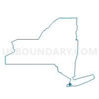
Maps

Graphs
Select a template below for downloading or customizing gragh for Voting District 5000080, Kings County, New York


Neighbors
Neighoring Voting District (by Name) Neighboring Voting District on the Map
- Voting District 5000070, Kings County, NY
- Voting District 5000081, Kings County, NY
- Voting District 5000082, Kings County, NY
- Voting District 5000083, Kings County, NY
- Voting District 5000105, Kings County, NY
- Voting District 5300007, Kings County, NY
- Voting District 5300008, Kings County, NY
- Voting District 5300012, Kings County, NY
- Voting District 5300025, Kings County, NY
- Voting District 5300029, Kings County, NY
Top 10 Neighboring County Subdivision (by Population) Neighboring County Subdivision on the Map
Top 10 Neighboring Place (by Population) Neighboring Place on the Map
Top 10 Neighboring Unified School District (by Population) Neighboring Unified School District on the Map
Top 10 Neighboring State Legislative District Lower Chamber (by Population) Neighboring State Legislative District Lower Chamber on the Map
Top 10 Neighboring State Legislative District Upper Chamber (by Population) Neighboring State Legislative District Upper Chamber on the Map
Top 10 Neighboring 111th Congressional District (by Population) Neighboring 111th Congressional District on the Map
Top 10 Neighboring Census Tract (by Population) Neighboring Census Tract on the Map
- Census Tract 513, Kings County, NY (4,332)
- Census Tract 501, Kings County, NY (2,786)
- Census Tract 497, Kings County, NY (2,645)